

SOMERSET BOROUGH ZONING ORDINANCE
ARTICLE I. TITLE AND APPLICABILITY
Section 1. Title
This Ordinance shall be known as the “Somerset Borough Zoning Ordinance, as amended.”
Section 2. Applicability
This Ordinance shall apply to the incorporated territory of Somerset Borough, Pennsylvania. It is the intent of this Ordinance that the extent of its applicability be automatically changed in accordance with the provisions of state law which may affect the applicability of this Ordinance.
ARTICLE II. PURPOSE
The zoning regulations and districts as herein published have been made in accordance with a Comprehensive Plan, to promote, in accordance with present and future needs, the safety, morals, order, convenience, prosperity and general welfare of the citizens of Somerset Borough, Pennsylvania, and to provide for efficiency and economy in the process of development, for the appropriate and best use of land, for convenience of traffic and circulation of people and good for the appropriate use and occupancy of buildings, for healthful and convenient distribution of population, for protection against destruction of or encroachment upon historic areas, for good civic design and arrangement including the preservation and enhancement of the attractiveness of the community, and for adequate public utilities, public services and facilities, by regulating and limiting or determining the height and bulk of buildings and structures, the area of yards and other open spaces, and the density of use. They have been made with reasonable consideration of, among other things, the existing use of property, the character of the district and its peculiar suitability for particular uses, and trends of growth or change, with a view to conserving the value of land and buildings and encouraging the most appropriate use of land throughout the incorporated territory of Somerset Borough, Pennsylvania.
ARTICLE III. DISTRICTS AND DISTRICT MAP
Section 1. Establishment of Districts
In order to regulate and restrict the location and use of buildings and land for trade, industry, residence, and other purposes, and to regulate and restrict the location, height, and size of buildings hereafter erected or structurally altered, the size of yards and other open spaces, and density of population, the following zoning districts are hereby established:
RESIDENTIAL DISTRICTS
R-1 Single-Family Residential District
R-2 Two-Family Residential District
R-3 Multiple-Family Residential DistrictBUSINESS AND COMMERCIAL DISTRICTS
B-1 Neighborhood Business District
C-1 General Commercial District
C-2 Central Commercial District
C-3 Commercial DistrictMANUFACTURING AND INDUSTRIAL DISTRICTS
M-1 Light Industrial District
M-2 Heavy Industrial DistrictFLOOD PLAIN DISTRICTS
FW Floodway District
FF Flood-Fringe District
Section 2. Reference to District Names
For the purpose of reference hereafter in this Ordinance, unless specifically provided to the contrary, the term “Residential District” shall include all Single-Family, Two Family, and Multiple-Family Districts; the term “Commercial District” shall include all Commercial and Business Districts; and the term “Industrial District” shall include all the Industrial Districts.
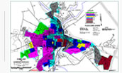
Section 3. Establishment of District Map
The district classification of the territory within the incorporated Borough of Somerset shall be as shown on the map designated as the “Zoning District Map, Borough of Somerset, Pennsylvania”, dated, signed by the President of Council, and attested by the Borough Secretary upon adoption. This Zoning District Map, and all notations, dimensions, references, and symbols shown thereon pertaining to such districts, shall be as much a part of this Ordinance as if fully described herein and shall be filed as part of this Ordinance by the Borough Secretary. Said Map shall be available for public inspection in the office of the Borough Secretary. Such map shall be marked “Original Copy, not to be altered or removed from the office of the Borough Secretary except on Court Subpoena”. This Map, together with subsequent applicable amendments, shall be conclusive as to the current zoning status of land.
Section 4. Informational Copies of District Map
Informational copies of the Zoning District Map shall be made available for inspection at the office of the Borough Secretary, Administrator, Engineer, and at such other locations as may be necessary or convenient. These Maps shall be revised to show changes in zoning district boundaries as officially approved. New streets, highways, subdivisions, major governmental installations, public lands, and other major features shall be shown. Drafting errors or omissions may be corrected, but no changes in zoning district boundaries may be made except to show amendments properly adopted by the Borough Council. Any person desiring a copy of said Zoning Ordinance or District Map shall pay cost sufficient to cover periodic revising and printing of the Zoning Ordinance and District Map.
Section 5. Periodic Review
At least once every five years, the Planning Commission and the Board of Adjustment shall review the zoning regulations and the Zoning District Map to determine whether it is advisable to amend the regulations or the Map, or both, to bring them in accord with the objectives of the Comprehensive Plan of the town, to take advantage of new techniques or to encourage improved building practices which may have been developed and which may have application in Somerset, to correct deficiencies or difficulties which may have developed in administration, or for such other reasons as the Commission or the Board may determine. The Commission and the Board shall submit reports on their findings to the President and Council. In the preparation of these reports, the Commission and the Board shall consult with officials in the town responsible for development of the Comprehensive Plan and the administration of this Ordinance, and such other persons as they believe may contribute to the review.
Section 6. Interpretation of District Boundaries
1. A district name or letter-number combination shown on the Zoning District Map indicates that the regulations pertaining to the district designated by that name or letter-number combination extend throughout the whole area in the town bounded by the district boundary lines within which such name or letter-number combination is shown or indicated, except as otherwise provided by this section.
2. Where uncertainty exists with respect to the boundaries of the various districts as shown on the Zoning District Map accompanying and made a part of these regulations, the following rules shall apply:
- In cases where a boundary line is given a position within a street or alley, easement, canal, navigable or non-navigable stream, it shall be deemed to be in center of the right-of-way of the street, alley, easement, canal, or stream, and if the actual location of such street, alley, easement, canal, or stream varies slightly from the location as shown on the Zoning District Map, then the actual location shall control.
- In cases where a boundary line is shown as being located a specific distance from a street line or other physical feature, this distance shall control.
- Where the district boundaries as shown on the Zoning District Map approximately coincide with lot lines, the lot lines shall be construed to be the district boundary line unless otherwise indicated.
- In cases where district boundaries as shown on the Zoning District Map do not coincide or approximately coincide with street lines, alley lines, or lot lines, and no dimensions are shown, the location of such district boundary lines shall be determined by the use of the scale appearing on the Map.
- When a district boundary line divides a lot held in a single and separate ownership at the time of the adoption of this Ordinance, the regulations as to the use in the less restricted district shall extend over the portion of the lot in the more restricted district for distance of not more than fifty feet beyond the district boundary lines; provided, that in case of a lot other than a corner lot, the regulations as to the use in a less restricted district may extend a distance of more than fifty feet beyond the district boundary line, when authorized as a special exception by the Zoning Hearing Board.
- In the case where interpretation is required concerning the exact location of any boundary of the Floodway or Flood-Fringe District, the Zoning Hearing Board shall make the necessary determination. The person questioning or contesting the location of the district boundary shall be given a reasonable opportunity to present his case to the Board and to submit his own technical evidence if he so desires.
ARTICLE IV. GENERAL PROVISIONS
Section 1. Compliance With Regulations
No building or land shall hereafter be used, and no building or part thereof shall be erected, reconstructed, converted, enlarged, moved, or structurally altered, unless in conformity with the regulations as set forth in the Ordinance.
Section 2. Location on a Lot Required
Every building hereafter erected, reconstructed, converted, moved, or structurally altered shall be located on a lot of record, and in no case shall there be more than one main building on one lot unless otherwise provided for in this Ordinance.
Section 3. Encroachment: Reduction of Lot Area
The minimum yards, height limits, parking space, and open spaces, including lot area per family, required by this Ordinance for each and every building existing at the time of the passage of these regulations or for any building, hereafter erected, shall not be encroached upon or considered as required yard or open space for any other building, except as hereinafter provided, nor shall any lot area or lot dimensions be reduced below the requirements of these regulations.
Section 4. Accessory Building: Prior Construction
No accessory building shall be constructed upon a lot for more than six months prior to beginning construction of the main building. No accessory building shall be used for more than six months unless the main building is under construction.
Section 5. Uses Not Permitted Are Prohibited
For the purpose of this Ordinance, permitted uses are listed for the various districts. Unless the contrary is clear from the context of the lists or other regulations of this Ordinance, uses not specifically listed are prohibited.
Section 6. Tables Are Part of This Ordinance
Many height, area, and bulk regulations applicable to each district are contained in a chart or table in Article 5. The table, and all of the notations and requirements which are shown in it or which accompany it, shall be a part of these regulations and have the same force and effect as if all of the notations and requirements were fully set forth or described herein. In general, the regulations applicable to a particular district are contained in the table to the right of the district name and between the same sets of horizontal lines. The regulations contained in the table are supplemented or modified by regulations contained in other articles of these regulations.
Section 7. Certain Regulations Not Reproduced Herein
Whenever reference is made in this Ordinance to any other ordinance, chart, table, schedule, or regulation which itself is not copied herein, a copy of such ordinance, chart, table, schedule, or regulation shall be kept on file in the office of the Administrator and available for inspection and reference.
Section 8. Minimum Requirements
In interpreting and applying the provisions of this Ordinance the same shall be considered as establishing the minimum requirements for the promotion of the health, safety, and morals and general welfare of the Borough. It is not intended by this Ordinance to interfere with, or abrogate or annul the rules and regulations of other municipal agencies of the Borough of Somerset or the provisions of the Building Code of this Borough, or any rules, regulations or permits previously adopted or issued thereunder: provided, however, that where this Ordinance imposes a greater restriction upon the use of buildings or premises, or upon the height of building or requires larger open spaces, than are imposed or required by such ordinances, rules, regulations or permits, the provision of this Ordinance hereafter shall control.